The Unified State Monitoring System for Sakhalin Shelf as the most important component of offshore zone development
 Special Research Bureau for marine research automation of the
Far East Branch of the Russian Academy of Sciences
Special Research Bureau for marine research automation of the
Far East Branch of the Russian Academy of Sciences
 Mikhail L. Krasny. The Chairman of the Sakhalin regional branch of Allrussian public body "Russian geographical society", as well as manages Scientifically - expert advice at administrations of Sakhalin region, also direct by Special Research Bureau of Automation of Marine Researches and many other sea projects and expeditions, including a grade oil-gaz shelf on South Kurily islands.
 Vasily N.Khramushin. Is marine navigator and fluidmechanics of ship by education in Kaliningrad Marine College and Leningrad Shipbuilding Institute. Science experience now is a computational fluid mechanics for oceanography, and - seakeeping for ship in strom.
Since 1996 one of the principal research topics of the Special Design Bureau for marine research automation of the Far East Division of the Russian Academy of Sciences (SKB SAMI DVO RAN) has been the search for ways to create an effective state system for monitoring and environmental control of oil-producing zones on the Sakhalin shelf. Scientific bases, technical facilities and organizational solutions for the development of such a sea monitoring system are being studied at the order of the Sakhalin Region Administration, with the direct participation of the State Committee for Ecology and Nature Conservation of the Sakhalin Region (Gossakhecologia).
| An automated monitoring system for the Sakhalin shelf can be created in the conditions of real development of modern technical means and systems for life support and navigation safety in offshore water areas of the Sakhalin Region. This facilities have to be utilized in accordance with the requirements of the international law of the sea and Russian legislation. |
At the initial stage of the research, the base concept of the creation of a unified monitoring system for the Sakhalin shelf was developed. It was prepared not only by Gossakhecologia, but also by employees of the Sakhalin Department for hydrometeorology and environmental monitoring (SakhUGMS) and Sakhalin research institute for fishery and oceanography (SakhNIRO). The results of the research were published in the book "Ways of creating a monitoring system for the Sakhalin Region shelf" in 1998 [1], where the following was established. During the initial stages, an informational and analytic system and an oceanographic database including materials of long-term observations in the Russian Far East seas should be created. Then the system has to be adapted according to the information from environmental monitoring operational services functioning on Sakhalin, and from the impact (local) monitoring services performed by oil companies. During the final stage, the monitoring system will have to be augmented with specialized telemetric measuring systems to eliminate gaps in operational information, which are necessary for comprehensive and efficient monitoring of both the entire Sakhalin shelf and the offshore oilfields.
Expected recoverable reserves on the Sakhalin shelf are estimated at about 2 billion tons of oil and condensate, and 3.6 trillion m3 of gas
[2]. Undoubtedly, the exploitation of the hydrocarbon supplies of our country's shelf is a principally new phase in the history of the development of the fuel and energy complex for the entire Far East Region. A lot of legal regulatory problems, as well as investment, technological, organizational and other issues have yet to be solved for the full-scale development of operations on the shelf. Thus, the problem of ecology and environmental protection is one of the most important during the implementation of oil production projects, which is stipulated by the extreme importance of the conservation of fisheries and bio-diversity in the Okhotsk Sea as a whole and especially in the Kurils region, since the latter is one of the most biologically fertile zones of the
ocean.
It is to be noted, that oil and gas on the Sakhalin shelf are explored and produced under extremely adverse hydrometeorological conditions: there are frequent storms and intense sea turbulence, in wintertime heavy ice floes from the Okhotsk Sea move at great velocity; the seismic situation in the region is unfavorable and anomalous and dangerous marine phenomena (seiches, extreme currents, hurricane winds and storm surges, seismic seaquakes etc) occur often. Under such conditions, the issue of ensuring the safety of offshore operations and advance warning of all potentially hazardous natural phenomena becomes extremely important, as does the implementation of an effective information system to support solutions to cope with the aftermath of emergencies, oil-spills and other irrevocable environmental consequences and disasters.
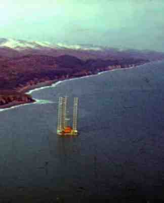
In 1998, a stationary ice-resistant platform, "Molikpaq," was installed on the Sakhalin shelf. The platform, together with a single anchor leg mooring and a storage tanker, "Okha", formed the first oil-producing complex in Russia, "Vityaz". In 1999, the "Vityaz" complex began oil production on the Sakhalin shelf. It was the first component of the marine infrastructure to resurrect the taiga regions of the north-east Sakhalin coast. The successful operation of "Vityaz" confirmed the high degree of technological readiness of the "Sakhalin Energy" company for performing offshore operations under such adverse conditions of the Sakhalin shelf.
In the next few years, the operations of the Sakhalin oil and gas projects are expected to expand substantially: it is planned to commercialize new sites, to commission a great number of offshore drilling platforms and to develop the production infrastructure of the Sakhalin Region as a whole.
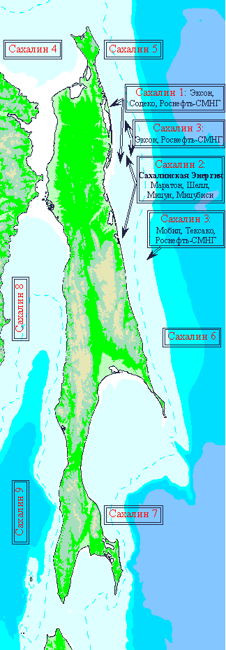 Fig.1. Developed and prospective oil and gas production sites on Sakhalin shelf
In this regard, the significance and necessity of developing marine oil-producing regions is growing: in particular, issues of state monitoring and control of environmental safety have to be solved, and an efficient system has to be constructed for the observation of conditions at sea, timely forecasting of dangerous marine phenomena, and ensuring the safety of navigation and offshore work, with obligatorily implementation of expert, analytical and information systems for quick response to oil-spills and offshore emergencies. In accordance with the technical capabilities of the state monitoring system, optimum and efficient alternatives for the allocation of staff and facilities have to be worked out, to provide a solution to problems connected with rescue operations at sea and with the elimination of the consequences of ecological
catastrophes.
The principal purpose of the automated monitoring system for the Sakhalin shelf is to ensure continuous and timely navigational and hydrometeorological support for offshore operations and navigation safety in offshore oilfields in general. The unification of the local systems for the monitoring of sources of pollution available at each marine platform is proposed as a technical policy for the creation of a state monitoring system. The key monitoring posts may be additionally equipped with measuring complexes for acquiring specific information important to carring out state environmental monitoring and control of sea areas. All the local monitoring stations and autonomous marine measuring complexes will be combined in a single network acquiring and transferring current information; the express analysis of the data will be performed in state departmental centers; the data of oceanographic or ecological significance will then be accumulated and thoroughly studied in an academic or a scientific sea condition control center.
Such an approach is chiefly predetermined by the necessity of accelerating the creation of a complex sea monitoring system; it also meets the requirement of optimizing expenses and efforts directed to the development of the system as whole. The basic equipment components and monitoring system techniques are well developed and ready to be implemented immediately to operate within the framework of the sea monitoring services functioning in Sakhalin. However, considering the basic marine environment and the extraordinary complexity of marine and atmospheric processes, all the components of the monitoring system have to be provided with continuous scientific and technical support, and be suitable for rapid modification to employ the latest achievements and results of basic research under the World Ocean program in order to ensure the practical effectiveness of offshore area
monitoring.
The current stage of developing practical procedures for the monitoring of the oil-producing regions of the Sakhalin shelf in the year 2001 has been prepared in accordance with the complex monitoring concept developed in SKB SAMI DVO RAN to the order of the Sakhalin committee for ecology and nature conservation in 1997-1998.
In accordance with the "Main organizational and operational principles of USMS * »" (Unified State Monitoring System), marine ecological monitoring may only be a secondary goal in a unified and complex system of the marine conditions monitoring, the overall solution to which must be implemented within the framework of the existing operational services of the Sakhalin Department for Hydrometeorology and Environment Monitoring (SakhUGMS), the Sakhalin Pilot Methodological Seismologic Party of the RAN Geophysical Service (SakhOMSP) and other organizations ensuring actual and continuous environmental monitoring. In particular, the following text was published in "Notifications for Mariners" [3], with a reference to RF legislation:
"Marine areas listed in
Legislation** and their mineral and biological resources shall be protected with a view to their
conservation, protection and optimum exploitation, and the protection of economic and other interests of the Russian Federation by the
following organizations within their own jurisdiction:
* Federal Border Control Agency;
* Federal Agency for Geology and Exploitation of Mineral Resources;
* Federal Mining Safety Inspectorate;
* Federal Fisheries Agency;
* Federal Agency for the Protection of the Environment and Natural Resources.
Operations of the above protective agencies have to be coordinated by the Federal Border Control
Agency."
| No matter how the unified system of continuous and express telemetric sea monitoring is realized, the operation of such a system will be considerably cheaper than occasional monitoring with use of scientific research fleet. And in the case of emergencies at oil-producing facilities, a telemetric complex continuously functioning under control of the "Nauka" center will be the only effective means to control offshore areas, and it cannot be substituted by no method of sea water inspection, even a super-high-speed or a super-expensive one, because it is necessary to know the current state of hydrodynamic and hydrophysic processes in the place of the sea catastrophe occurrence in order to forecast the development of the dangerous situation in the sea. |
The hydrophysical and ecological parameters of the marine environment have to be subject to constant and efficient monitoring to ensure the safety of oil production activities on the Sakhalin Shelf, especially in wintertime and during autumn and spring storms; this is also necessary to perform ecological control in the shelf zone. Oil-extracting services and crews of drilling units have to be provided with a full set of storm warnings, timely forecasts of dangerous marine phenomena and exact data on changes in seismic activity in regions where natural gas is extracted.
Thus top priority is assigned to the task of ensuring the safety of offshore work in general. This is determined by the general situation in a marine area constituted by navigational, hydrometeorological, informational and cartographic support, the availability of communication facilities and instruments controlling the condition of the sea and the atmosphere, as well as the presence of continuously operating coastal services forecasting and warning of dangerous sea and natural phenomena.
Conventionally, offshore zone monitoring, including ecological observation, is primarily characterized by the length and frequency of practical surveys of various parameters of the state of the water, the sea surface and the lower atmospheric layers, carried out directly in the sea:
1) Occasional observations are carried out without any pre-established monitoring programs . Such observations have to be carried out if any unusual, anomalous phenomena have been discovered, or if marine conditions have to be urgently and exactly determined to work out solutions to prevent any irrevocable or ecologically dangerous processes taking place. Unfortunately, only occasional observations are currently carried out in the oil-producing zones of the Sakhalin shelf, with the last standard survey carried out about 10 years ago. In the 90s, oil-producing companies carried out limited ecological observations on the Sakhalin shelf. They were chiefly performed in response to specific orders of an industrial or auxiliary character. Since 2000, the reestablishment of regular state monitoring of marine oilfields on the Sakhalin shelf has been begun. In 2000, the first background oceanographic survey was performed to practically amend unsystematic oceanographic materials obtained earlier by oil companies through occasional observations.
2) Regular surveys are carried out yearly with identical time periods distributed among the different seasons, in accordance with the preliminarily approved and agreed scientific programs. Standard measuring equipment has to be used during regular monitoring, and authorized hydrographic services and state departmental agencies responsible for the control of the marine environment have to participate. In the case of the Sakhalin shelf, such monitoring will only make sense if performed as a complex and together with inshore observations, and with concurrent monitoring of both Sakhalin rivers and the river Amur. The latter substantially contributes to the hydrologic state of Sakhalin shelf waters. Both methods and instrumentation of oceanographic surveys have qualitatively changed over the last 10 years, while the regular monitoring of the Sakhalin shelf was not performed. Hence, the complex marine expedition planned for the year 2001 also has the task of developing and testing new sea monitoring methods, including those using data of remote sea surface probing from space.
3) Continuous Observations can be carried out with the use of modern telemetric measuring instruments and remote systems for ocean surface probing from the coast, on board oil-producing facilities and from space. Such continuous monitoring is the only efficient means to forecast and prevent uncontrolled development of irreversible ecological processes in the sea as well as to work out reasonable decisions to prevent marine emergencies and disasters or to carry out urgent operations to eliminate the aftermath of such emergencies and oil-spills in the sea. Continuous monitoring can be performed with a limited set of environmental parameters and at a restricted number of constantly operating telemetric monitoring posts, which can be most conveniently organized at coastal lighthouses and coast-guard stations, as well as at oil drilling platforms and support vessels. These limitations mean that "Regular" and "Occasional" monitoring retain their importance. They are needed to ensure periodic comparison and joint analysis of complex monitoring results for extensive sea areas and long-term telemetric control data. If continuous monitoring and regular survey are organized in accordance with a common scientific and engineering program, a unified operational (crisis) center can be created to control Sakhalin shelf offshore areas (let us call it the "Nauka" center). In this center, in the intervals between expeditions, data from telemetric monitoring centers located far away from one another will also be used to control extensive marine zones, with the utilization of computational experiments continuously carried out in real time.
As in any design task, during the creation of a closed system, a task is set where only the conditions, called "necessary" in mathematics, are determined, or, when new or complicated systems are developed, the "sufficiency" concept for facilities and efforts necessary to complete the initial design goals is absent. When the purpose is defined comprehensively and the basic operational principles of the future system are known, a method of logical investigation of the new system operability in a single complex, may be used to estimate the result of the design work. In practice, however, the process of designing and putting into operation new high-end technologies may be extremely long, or endless if the purpose is incorrectly defined. Can the viability and functional integrity of a continuous sea monitoring system, be estimated at every stage of its creation, when practically important results may already be obtained at the initial steps of the process. ? The mechanism for estimating the coherence of different design solutions may be analyzed through the use of ternary logic in which any theoretic assumptions can be uniquely mapped onto specific practical
applications.
Let us suppose that the major design purpose is the viability, optimality and effectiveness of a technically sophisticated system. These parameters have to be evaluated at a lot of stages during the development. Taking into consideration the long term view of putting the system into operation, a logical basis has to be constructed that allows technical solutions to be analyzed for their coherence at all the stages of their design, development and practical application, including intermediate steps of the monitoring system during evolvement. Considering the optimal realization of scientific, engineering and organizational solutions, such a complex design estimate can be conveniently systematized as a three-dimensional logical basis where each of the axes determines key directions of practical work or scientific research. Each axis is orthogonal to (independent of) the other two logical axes.
 "OXa" on f sea bank |
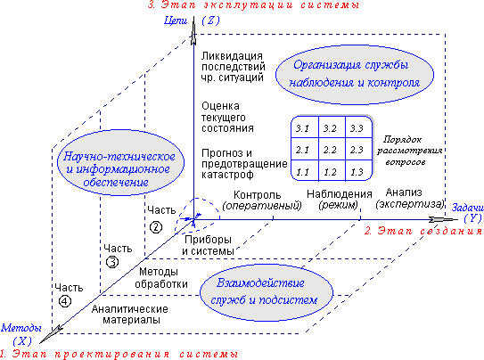 Fig. 2. Logical basis for the design, creation and application of the Sakhalin shelf express monitoring and control system.
(Task groups divided into stages are represented in Figure 2 as three basis axes forming independent directions of work and research, which are systematized using a three-dimensional (spatial) logical
basis).
Fig. 2. Logical basis for the design, creation and application of the Sakhalin shelf express monitoring and control system.
(Task groups divided into stages are represented in Figure 2 as three basis axes forming independent directions of work and research, which are systematized using a three-dimensional (spatial) logical
basis).
Through such systematization of logical objects and operations on them (Fig. 2), each reading on any basis axis can be characterized in terms located in the plane of the related orthogonal logical axes.
The design stage
1. Scientific and engineering facilities and instruments available:
1.1. Instruments and systems for oceanological and geophysical observations;
1.2. Data analysis, extrapolation based on area and future forecasts ;
1.3. Systematization of analytic materials, simulation of physical processes.
The creation stage
2. Control and monitoring methods, legal and administrative issues:
2.1. Express control of hydrometeorological and hydrophysical parameters;
2.2. Regular monitoring of the Sakhalin shelf condition;
2.3. Continuous expertise and analysis of the general state of affairs.
The monitoring and control system application stage
3. Factors determining the purposes, objective and time of monitoring
3.1. Prevention of disasters and warning of ecological danger;
3.2. Investigation, control and analysis of current ecological situation;
3.3. Minimization of harmful effects and elimination of ecological catastrophes.
The current state of affairs may be described as the initial steps of designing the complex monitoring system for the Sakhalin shelf, which is determined by the axis X in the logical basis as selection of basic methods and promising technologies. The three secant planes on the Y and Z axes demonstrate that issues connected with applicable instruments and techniques require triple (comprehensive) consideration; these issues have to be developed for the purposes of obtaining results important to increase the general technical level (i.e. information and technical facilities) of offshore work on the Sakhalin shelf in the future. Each group of design subjects is a flat logical matrix along the Y and Z axes. The meaning of the elements of this matrix enables surveillance methods to be studied comprehensively, while taking into consideration scientific, engineering, organizational and legal issues of the designed monitoring service and system.
Even though the logical designing of a complex monitoring system as a functionally unified system for sea situation monitoring is very important, the environment in which the project is to be implemented, should be addressed in the very beginning. Socioeconomic conditions in the Sakhalin region must be taken into consideration to provide the necessary motivation.
1. Scientific research. Among the high-priority tasks, the practical implementation of hydrodynamic, hydrophysical and hydrometeorological computational experiments have to be indicated. They have to create a methodological basis for continuous monitoring and control of offshore areas, and must ensure the operation of telemetric measuring complexes and marine expert and analytical systems. Due to this, methods of using modern instruments for express monitoring throughout a network of scattered stations observing the current sea condition can be studied, and materials of historic observations and research expeditions carried out on the Sakhalin shelf, can be revised in order to substantiate the entire complex of activities connected with the creation of a modern sea monitoring system.
2. Information support of monitoring and control of the Sakhalin region offshore zone is a science-intensive activity; it has to be directed to retrofitting and perfecting the sea and environment monitoring facilities functioning on Sakhalin. It is to be taken into account that operations connected with sea monitoring will still be confined to academic laboratories for a long time. Hence, the researches will only be the most effective if oceanographic materials are accessible for all involved agencies, scientific organizations and competent scientists and engineers. The information support of the monitoring system should be constructed on the basis of the sea center "Nauka", as it is the scientific oceanographic laboratory of the Russian Academy of Sciences. It has to form the base of an information and analytic center as it is equipped with publishing facilities; in particular, it has the capability of publishing the most important materials on electronic carriers. The monitoring system information support itself should be started with the creation of a network information resource (a server) integrated in both a public net, like the, Internet and in industrial systems of communication and oil production control.
3. A complex sea monitoring system itself is very expensive and technically sophisticated. Nonetheless, such a system can be created provided that, first, it will be integrated in production services and oilfield control systems; second, the system will be created on a strict and unified scientific basis (Clause 1) under conditions where a public information system of sea monitoring is available (Clause 2). The complex monitoring system can be created by the efforts of Sakhalin scientists and engineers. It has to be developed with the maximum use of the potential of Russian oceanological science, and the system itself has to present a natural consequence of long-term researches in the Okhotsk Sea region. In developing such a system, the experience of oceanographic researches throughout the world should naturally be taken into consideration, but the requirement for the succession of the Russian scientific school must be decisive, with the priority of continuation of the long-term cycle of sea standard monitoring being ensured.
Maintenance of sea-based facilities , as well as standard and express processing of measurement results, must be carried out by the respective departmental agencies: SakhUGMS and SakhOMSP. The above-mentioned center "Nauka", which is actually a scientific laboratory, will be able to take part in solving unconventional and scientific problems. Its principal tasks must include the participation in technical retrofitting and improving the work schedule of existing operational services on Sakhalin, in particular, the participation in the practical utilization of new instruments consisting of high-performance computers, software and electronic systems for acquisition, analysis and targeting distribution of express information.
During the first stages of operation of the information and analytical center "Nauka", numerical simulation will be confined to the extrapolation from scattered observations to larger water areas of the Sakhalin shelf, and to the accumulation of data on current hydrophysic processes and the water condition. As new information and computing systems are put into action, after the express data channels are perfected, the monitoring center (irrespective of what base it was created upon ) will have to take part in complex information support (in the production respect) of oilfields, which should create the background for carrying out effective ecological monitoring.
Without detailed consideration of currently available basic complexes of information and instrumentation support, let us discuss organizational and methodic issues of designing a complex monitoring system in the oilfield regions on the Sakhalin shelf. In the logical plane of the project (Fig.2) the objectives and targets of the express forecast of dangerous situations, continuous and complex monitoring, and the creation of an effective information support system for the elimination of consequences of natural and man-caused catastrophes, are repeated again. (see below: clauses 1.x ÷ 3.x.). Organizational and technical measures ensuring the achievement of the indicated objectives, are determined along the independent (orthogonal) axis in this logical plane (see below: clauses x.1. ÷ x.3.).
1.x. Express control and analysis of the situation in the sea, with a view to forecasting and warning of dangerous sea phenomena, ice motions, earthquakes and tsunamis that threaten human life or can bring catastrophic consequences in the case of damage to, or destruction of, oil-extracting equipment;
2.x. Continuous and periodic control of the ecological situation in the oilfield region and on the entire Sakhalin shelf with a view to preventing irrevocable and destructive natural processes, both in the waters of the Sakhalin shelf, and in zones where equipment is concentrated or where oil pipelines are run across the island territory or in the sea.
3.x. The maintenance of the constant readiness of information facilities supporting emergency and rescue services, which must possess reliable information to make decisions on how to eliminate an emergency at an oilfield, or organize effective measures for eliminating catastrophic consequences. In this respect, it is necessary to align with services operating in the Sakhalin region and in oil-producing companies, and the unified system of express information and expertise support of these services should be accepted for development.
These objectives can only be achieved if the existing departmental services are involved; currently, their participation in express environmental monitoring in the Sakhalin region is insufficient. These services work in accordance with approved state techniques which are based on instructions regulating decision-making in emergencies. These manuals have to be improved continuously to take into account the changing economic and sociopolitical conditions in the Sakhalin region.
While searching for optimum solutions to the creation of a unified monitoring system on the Sakhalin shelf, existing monitoring services and systems have to be improved. In this process, the new oceanographic laboratory (of the "Nauka" center) can play the role of a scientific and engineering service performing a complex of science-intensive operations and services connected with the creation, development, trial and long-term maintenance of new sea monitoring and control systems.
x.1. Local monitoring systems in the oilfield region:
1.1. Hydrometeorological situation, seismic monitoring and storm warning;
2.1. Local automated system for hydrophysical monitoring and sea surface control;
3.1. Maintenance of the active state of computational models of hydrodynamic conditions of currents, the interaction between the atmosphere and the ocean, the dynamics of sea level changes, the wave climate etc, though updating them with express data supplied by UGMS services and in-house local monitoring systems.
x.2. Specialized service controlling the situation in the oilfield zones:
1.2. The integrated automated processing of data supplied by SakhUGMS and SakhOMSP services, and from oilfield zones and continuously operating in-house monitoring systems, as well as material from current field inspections;
2.2. Reception and specific processing of data on sea surface remote probing from space. Accumulation of the data of environmental monitoring in oil-producing regions. Continuous updating of specialized information systems adapted to solving operational objectives and satisfying expert inquires;
3.2. Maintenance of the network information resource
(an electronic communications center and data server), where current and express information about the environmental conditions will be provided for everyone working on the Sakhalin shelf (including fishermen, oceanologists, scientists, the military etc.). On the same data server, initial and analytical (forecast) materials concerning all adjacent water areas, required to adjust computational and interpolation models of local monitoring, have to be provided. Systematization of data received form different services and monitoring systems, continuous numerical simulation of hydrodynamic condition of the water area covering all oilfield zones, with the collected data being automatically presented at a public network resource.
x.3. The expert and analytical service and the group of scientific and engineering support:
1.3. Maintenance and updating of measuring systems and information complexes have to be performed by the same scientific groups and existing operational services that will take part in design, development and implementation of the monitoring system;
2.3. Detailed analysis of current information, establishment of potentially dangerous anomalies, and development of efficient methods for preventing hazardous situations and emergencies, have also to be performed by other scientific organizations and groups of workers when necessary;
3.3. The oilfield condition monitoring center, must have a preliminarily designed plan for gathering responsible specialists and experts. In this center, automated workplaces have to be provided, maintained in constant readiness for the utilization of numerical models, information systems and communications means, which have to be be put into operation at a signal that gives warning of a hazard in oilfield zones of the Sakhalin shelf.
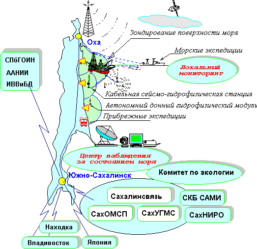 Fig. 3. Designed layout of location and interaction of operational services and sea monitoring systems in the Sakhalin region
A unified monitoring system in oil production zones may be organized as a group of local subsystems, each of them responsible for ecological conditions in the marine zone adjacent to the drill platforms. Each of such local subsystems can perform direct instrument monitoring of the sea condition, ecological parameters of the water and ensure making substantiated decisions during production and maintenance activities that are connected with having an impact on the environment. The same express control instrumentation for offshore zones have to be used to ensure safety of offshore operations in the open sea and be involved in the rapid analysis of the sea condition during emergencies and ecological catastrophes.
If proper technical means are available, observations of the condition of the sea and the atmosphere should be carried out with the use of automated telemetric complexes that have to be combined into a unified network to collect hydrophysical, hydrometeorological and ecological data from all local monitoring posts. This will enable systematization of data for the preparation of hydrometeorological forecasts of dangerous sea phenomena, the information about which have to be made known in accordance with the schedule for distributing storm and other urgent warnings. The basic parameters necessary for production activities of drilling platforms have to be provided to watch services of drilling platforms and oil-extracting units. In the case of a unified monitoring system, analytic information from the common sea monitoring center can be provided for drilling platforms.
When a monitoring system is created following such a principle, the requirements for specific information for oil production operations, both under regular conditions and in the case of emergencies, or the implementation of a oil-spill elimination plan, have be considered from the very beginning, which is also a requirement of the International Sea Organization for ensuring human safety in the sea. This substantiates the participation of oil-producing companies in the development of complex sea and atmosphere monitoring, which can substantially optimize the total expenses for the creation of the general engineering infrastructure of sea monitoring.
In the picture above, a generalized plan of the complex monitoring organization for the Sakhalin shelf is shown. It is indicated that the basic complex of hydrometeorological and seismological observations has to be carried out by state operational services functioning on Sakhalin, by SakhUGMS and SakhOMSP specifically, with the Sakhalin Communications Department (Sakhalinsviaz) and the Federal Agency for Governmental Communications and Information (FAPSI) participating to provide the monitoring systems with telemetric communications channels and facilities for express delivery of warnings of storms and dangerous sea and natural phenomena.
A local monitoring system has to solve the complex of operational tasks connected with ensuring the safety of navigation and offshore operations. Current analytical information from this system is very important for making decisions when fighting for the survivability of drilling platforms and when eliminating the consequences of emergency oil-spills. The entire complex of measuring, informational and analytical facilities can be constructed on the basis of a hydrometeorological post and be operated by the watch team of the offshore oil-extracting unit. In the organizational and technical respects, the local monitoring system can be divided into the following subsystems:
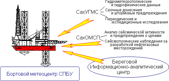
Fig. 4. The plan and content of local monitoring, carried out immediately in the oilfield areas.
|
1. Environmental monitoring, analysis of current situation. |
2. The complex of simulation and forecast of dangerous marine and natural phenomena |
3. Expert and analytical systems support decision-making |
|
1.1. Acquisition, processing and analysis of data received from the ship meteorological post, the local monitoring system and production and maintenance services. |
2.1. Continuous control of marine areas with the use of models adapted to the introduction of amendments from telemetric systems (- »1.2 |
3.1. Scientific research intended to test and improve methods of monitoring, simulation and data analysis. ( - » 1.3. ) |
|
1.2. Receipt of urgent notifications and storm warnings from existing operational services, systematization of these data and their introduction in the on-board information system. |
2.2. Continuous numeric modeling of the hydrodynamic situation with taking into consideration the interaction between the atmosphere and the ocean, with amended analysis for adjacent water areas. |
3.2. Periodic comparison of the hydrophysic ecological data on marine conditions obtained through simulation and analysis of the whole complex of telemetric information. ( - »2.3 ) |
|
1.3. Updating the on-board database and the information system on environmental conditions. Automated preparation of boundary and initial conditions for continuous numerical simulation and of initial data for expert computer systems. |
2.3. Computational predictions and modeling of possible consequences of dangerous sea phenomena, tsunamis, earthquakes, ice movements and other hazardous natural events, including those caused by production activity and emergencies at self-propelling floating drilling units. |
3.3. Utilization of a computer expert and analytic system for making the most contemplated decisions taking into account the former experience of self-propelling floating drilling unit operation, when preparing for work during storms, when fighting for survivability, or in the cases of other contingencies and emergencies. |
1. Process monitoring of the volume and concentration of harmful substances in drilling mud and spoil dumped into the sea. This control has to extend up to the edge of the area of influence, where the pollution should decrease to background levels or to the maximum allowable concentration. The responsibility for decision-making connected with dumping noxious substances in the sea may be imposed on the master borer (the head of the self-propelling floating drilling unit) who determines the schedule and volumes of discharges based on the present condition of sea flows and selecting times enabling maximum dissipation of noxious admixtures or, in accordance with the forecast of minimal sea currents, promoting the sedimentation of heavy suspensions in the immediate proximity of the drilling platform;
2. Hydrophysic control of the composition of seawater, sea-bed sediments and the sea surface is carried out with recording instruments enabling monitoring in the immediate proximity of the points of drilling and oil extraction. The hydrophysic control system not only provides independent recording of the harmful impact on the environment, but also helps the master borer to draw up the schedule of discharges ensuring the minimization of the unfavorable effect on the marine environment.
3. Hydrometeorological and seismic observations
, acquisition, analysis and continuous monitoring of marine conditions with the use of both local technical facilities and urgent information and storm warning received though communications channels from hydrometeorological and seismological services. An automated workplace for an observer-hydrometeorologist must be provided onboard a drilling platform. The place should include computational models for timely analysis of different alternatives of production impact on the environment, as well as for forecast and simulation of dangerous sea phenomena. The models should be adapted to emulate different courses of action in
emergencies.
Local monitoring is carried out by the production and maintenance services of oil-production units. The reliability of the information received from local posts can be ensured via organizational and engineering measures based on the controllability of the main expert and analytical center that performs continuous and express interpretation of the whole complex of oceanographic information, including that received from in-house instrumentation complexes, as well as from state monitoring and control
services.
The onboard information and computing complex must not only maintain the serviceability of the in-house local monitoring system and communications facilities transmitting information from the system to the major center, but also provide operation modes for solving current oil-production and operational tasks:
1. The routine stand-by mode:
1.1. Automated acquisition and systematization of hydrometeorological and seismological data, obtained from state agencies and the specialized monitoring center. Hydrometeorological data have to be automatically converted to be used as the initial conditions during numerical simulation of the hydrodynamic conditions on the Sakhalin
shelf.
As a result, the computer CRT will display a current weather map (a surface analysis) that has to be interpolated to real time and compared with the results of numerical simulation of the dynamic of the atmosphere and the
ocean.
1.2. Automatic acquisition, processing and storage materials received from the local monitoring system and production and maintenance services of a self-propelling floating drilling unit. After the received data have been specifically processed, they should be used to establish more precisely (to adapt) the numeric simulation and for express amendment of forecast models and techniques for evaluation of dangerous marine phenomena, and for warning of natural and man-made earthquakes
As a result the computer CRT will display the information on the storm navigability, rough-water stability on the float, or stability of the self-propelling floating drilling unit on the ground; maps with the present velocity field distribution of sea currents, concentrations of suspended impurities and those precipitated on the sea-floor; these data are obtained through numerical simulation with the use of express results of local
monitoring.
1.3. The tidal conditions and the state of tidal and constant currents must be continuously modeled in the background mode on the stand-by computer, taking into account express data received from the instruments of the local monitoring system, through urgent distribution and warning notifications of SakhUGMS and SakhOMSP, and specific data and initial materials provided by the unified monitoring
center.
This modeling will virtually substitute for the interpolation procedure intended to reproduce spatial hydrophysical and hydrodynamic fields in the Okhotsk sea and on the Sakhalin shelf. The distinctive feature of numerical hydromechanical modeling is that long preliminary calculations are necessary to obtain the current hydrodynamic field, and they have to be constantly controlled by a mathematician-engineer until the real tidal field is determined. Since there is no time for calculations during emergencies or when immediate decisions are to be made, this modeling can be carried out only in the conditions of a continuous computer experiment carried out in real-time. So, when a necessity to model dangerous sea phenomena, tsunamis, ice movements etc. arises, the decision can be copied from the constantly calculating computer to another one with special expert and research mathematical software installed, where dangerous situations will be simulated far ahead of real time (in the mode of forecasting dangerous sea phenomena).
Similar calculations have to be executed in the case of oil-spill emergencies when the actual schedule of tidal and storm currents, the character of waves and the directions of extension of oil patches can only be forecasted by direct numerical modeling of shelf water hydrodynamics.
The above-described sea monitoring system can be highly efficiently used to ensure the safety of offshore work and to prevent emergencies.
The problem of sea monitoring in oilfield zones cannot be comprehensively solved by only organizing local monitoring. First of all, it is stipulated by the peculiarities of the hydrodynamic and hydrometeorological conditions in the sea, where, as a minimum, the conditions of waters of the entire Okhotsk sea and the northern part of the Pacific have to be controlled to evaluate the situation in a particular region of the Sakhalin shelf.
|
State |
Oil-producing companies |
Science |
|
|
Users |
Fleet observation services |
Offshore drilling units and the administration of oilfields |
Russian Hydrographic Agency, |
|
Performer |
Russian Hydrographic Agency, |
Meteorological posts of offshore drilling units |
SKB SAMI |
|
Çàêàç÷èêè |
Russian Government, |
Sakhalin Energia, Exxon, |
Russian Academy of Sciences |
The most comprehensive solution to the indicated problem will be possible if the specialized information and analytical center "Nauka" is established; it should accumulate data from all the local and autonomous monitoring systems and from satellite monitoring, obtain urgent and storm warning from Russian and foreign sea monitoring systems. After specific processing, these data have to be sent to the meteorological posts of drilling platforms and be used as initial data for local monitoring systems.
| Since any activities in the open sea are extremely difficult and expensive, and will still long remain at the stage of scientific research and will always need the application of results of long-term observations and the utilization of data from Russian and foreign agencies involved into sea monitoring in their routine operation, the idea of commissioning this work to little commercial companies must be rejected from the very beginning. Besides, it will never be feasible to organize a profitable enterprise ensuring human life safety in the sea without weakening the state interests of Russia in its own territorial waters. |
The monitoring center "Nauka" should function under operational mode and be part of an authorized state marine service. However, considering the novelty and science-intensity of the problems it solves, at initial stages such a center can exist as a part of an academic oceanographic laboratory. In this case, the systematic development and constant improvement of the monitoring system will be ensured under conditions where complicated problems will be put to scientific and engineering trial, and new technologies will be handed over to existing organizations, with the operational personnel being trained and proper scientific and engineering support provided.
Sea monitoring is among the direct duties of SakhUGMS, as well as the seismologic observations which have to be and are carried out by SakhOMSP. In the contemporary circumstances, any substitution or duplication of the functions of these state agencies can result in irrevocable consequences, the destructiveness of which can exceed the revenues from oil and gas projects or make their realization principally impossible.
The Uzhno-Sakhalinsk City segment of the sea monitoring system has to connect the monitoring systems of SakhUGMS, SakhOMSP, Sakhalinmorneftegas, SKB SAMI, IMGiG, the Sakhalin Committee for Ecology, the Head Department for GO and ChS, the Sakhalin Region Administration and other involved organizations into a unified information network. The segment has to be created and maintained by SKB SAMI;
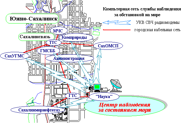
Fig. 6. The Uzhno-Sakhalinsk segment has to connect major operational services through high-speed radio-modems into a common computer network. At the same time each information resource has to be included in the city cable data transfer network, which enables access to the information for other users.
An expert and analytical monitoring center can be formed on the basis of a scientific organization of the Russian Academy of Sciences, and the Special Design Bureau (SKB) for marine research automation. This proposal can be substantiated by the following cases:
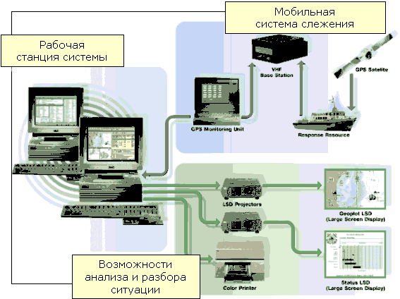
Figure 7. Structural flowchart and the relationship of equipment in the automated system controlling fleet during elimination of oil-spill consequences.
One of important component of the monitoring system is the creation of an operational center for acquisition, analysis and accumulation of results of remote sea probing from space. This task can be accomplished in the following sequence:
The Sakhalin Region Segment has to connect information resources of the cities of Yuzhno-Sakhalinsk, Okha, Kholmsk and Korsakov with other cities in Russia and worldwide where there are representations of Sakhalin's oil-producing services and companies. The segment of digital communication is exclusively controlled by joint-stock company Sakhalinsviaz (Yuzhno-Sakhalinsk telegraph and telephone exchange, TTE), which is the owner of the regional data network functioning as a regional component of the worldwide data network x.25 Sprint.
Depending on the complexity of network services provided by the Sakhalin TTE, the data network usage mode is divided into two categories:
1) Connection through a dedicated line of round-the-clock operating computers (e-mail, the communications center) or terminal equipment working with the x.25 protocol (terminal concentrators, packet switch centers);
2) Registration and support of user's network ID, designed to authorize the user when they access to network resources through network nodes.
The Marine Segment is formed by HF and VHF/UHF radio data channels between offshore facilities and district communications center. This provides drilling units with modern means of communication and creates the prerequisites for incorporation of the fleet and drilling units into Sakhalin and worldwide data networks, including Interned;
The segment of telemetric informaion aquisition from offshore hydrophysic and seismologic measuring complexes. The segment is formed by underwater cable systems run from board of offshore drilling units. The expenses for operation of such a telemetric monitoring system can be substantially optimized provided that industrial communications facilities of oil producing companies and state data channels of the GMSSB, the Federal border control agency and the Ministry for transport are used. The channel for data acquisition for autonomous recording instruments, both buoy-mounted and drifting, may be formed by satellite systems like ARGOS and Gonets, which will transfer telemetric data to Uzhno-Sakhalinsk through cost-optimized electronic communications channels.
 General work safety and environment protection regulations.
The creation of new Russian operational safety and environmental protection regulations for development of offshore hydrocarbon resources proposed in the feasibility study of a Russian-American-Norwegian project [4], has to be based on a "balanced development" concept. This means that the exploitation of natural resources must not create a threat to the interests of future generations, the environment, and the local population health.
The new regulations must also take into consideration the interest of aboriginal northern peoples and aim to minimize the adverse effect on their economic, social and cultural needs and human health.
The future operational safety and environment protection regulations have to include the following provisions:
 General conclusion
In accordance with the concept of complex sea monitoring described here, the development of an information system integrated in express information flows from operational services and monitoring systems operating on Sakhalin is the first-priority and most important objective. The achievement of this goal will form the basis for designing and creating all other technical monitoring facilities and systems.
Namely:
1) Using data on the current sea situation systematized in the information system, computer complexes have to be created for advance simulation of the interaction of the atmosphere and the ocean; other issues of expertise and analysis and standard forms of the representation of current information have to be developed.
This is necessary to obtain timely forecasts of dangerous sea phenomena and take measures to prevent emergencies and contingencies. Thematic archives accumulated in the same information and cartographic system have to be used to make reasonable decisions on actions in the case of the deterioration of the ecological situation.
2) When developing scientific and practical monitoring objectives, the need will surely arise for conducting a comprehensive survey of inshore water areas, the result of which will require for the implementation of additional telemetric systems for express sea monitoring in specific points of shelf zones. The location and number of such points have to be optimized to ensure the information reliability and the precision of computation experiments in the desired information and cartographic system.
3) As of 2001, it is to be noted, a package of legal acts concerning the issues of operating in the economic zone and the territorial sea of the Russian Federation was developed and approved at the federal level. Hence the practical implementation of the entire complex of measures to evolve real sea monitoring and control systems in the Sakhalin region can be started.
REFERENCE
1. M.L. Krasny, V.N. Khramushin, V.A. Shustin, V.V. Volovsky, A.B. Gromov, E.G. Zolotukhin, V.M. Pishchalnik, "Ways of creating a monitoring system for the Sakhalin Region shelf" (rus.), Sakhalin publishing house, Uzhno-Sakhalinsk, 1998, 208 p.
2. Oil Company "Rosneft" 1995-2000, M. 2000, p.16.
3. Notifications for mariners, Issue 1, part 1, January 4, 1999, the Hydrographic Service of the Red-Flag Pacific
Fleet.
4. The feasibility study of the Russian-American-Norwegian project "Operational safety and environment protection regulations for oil and gas exploration and extraction in the Russian offshore zone". "RANAK", Moscow, 1998
 *
*
1.1. Environmental monitoring is the execution of observations of natural environment parameters, with specially established spatial, temporal and component resolution, the evaluation of their condition and prediction of expected changes.
1.2. Ecological monitoring is the monitoring of human impact on the natural environment and changes in the state of the environment and ecological systems, carried out to estimate the condition of the natural environment and predict possible changes. Basing on this information, long-term and immediate guiding solutions are worked out in the sphere of environment protection, nature conservation and ecological safety ensuring.
1.3. Ecological monitoring accomplishes the following tasks to achieve its established purposes:
-identification of a monitoring object and formation of its conceptual and informational model;
-ensures the acquisition, processing and storage of complete, reliable and comparable information about the condition of the objects of monitoring;
-complex and thematic analytic data processing;
-conveys ecological monitoring data to interested customers in due time;
-agreed methodological and metrological support of environmental monitoring.
**
"Act of the continental shelf of the Russian Federation" (put into effect 7.12.95); "Act of the exclusive economic zone of the Russian Federation" (17.12.98); "Act of the internal marine waters, the territorial sea and the inshore zone of the Russian Federation" (31.07.98).